
Object profile · ARIEL
Ariel
Bright, geologically renewed major moon of Uranus
The brightest major Uranian moon, crossed by fault valleys and younger deposits that record past internal activity.
- Atlas data reviewed
- Editorial stage
- Published
- Visibility
- Public
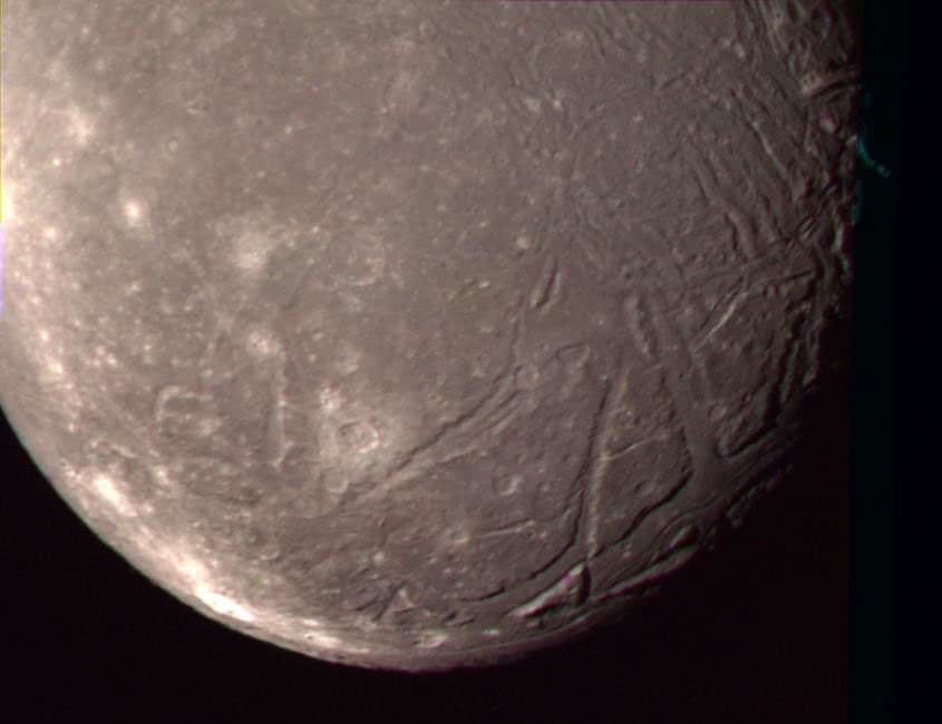 Direct observation
Official multi-filter color composite. Coverage favors the southern hemisphere, and the displayed color is processed.
NASA/JPL ↗What this world is
Ariel is not a smooth ice ball. Long valleys bounded by faults cut older cratered ground, and some valley floors contain younger material.
Why it looks this way now
Voyager 2 directly saw young-looking valleys and resurfaced areas. A 2023 thermal model allows a residual briny ocean, but no spacecraft has measured that ocean directly.
Where it sits
The second of Uranus' five major moons, between Miranda and Umbriel on a regular prograde orbit.
Swipe sideways to inspect the full map
Ariel is 2 of 5 profiled Uranus moons by distance, at a mean center distance of about 190,929 km.
The left panel locates Uranus, dashed lines mark the scale change, and muted orbits and dots represent other profiled moons on the right. Miranda is the adjacent profiled moon inside; Umbriel is adjacent outside.
Read the numbers
Reference values retain their units, context, evidence state and published uncertainty.
Physical measurements
- Mean radiusglobal mean
- 578.9kmCalculated measurementThe mean radius is about 0.333 times the radius of Earth's Moon.
Irregular moons have no single true radius; the mean radius is an equal-volume comparison.
Published uncertainty: ± 0.6 km
JPL tabulated uncertainty for the adopted mean radius.
- Massglobal mean
- 1.251068E21kgCalculated measurementMass is not read from a scale. Motion under gravity constrains GM, from which mass is derived.
Calculated from JPL GM with a conventional gravitational constant, then rounded for display.
Approximate value
Derived from JPL's gravitational parameter GM and a conventional gravitational constant, then rounded.
- Mean densityglobal mean
- 1.5390g/cm³Calculated measurementDenser than pure water ice, consistent with a mixture of water ice and silicate rock.
This is a whole-body average and cannot by itself prove the composition of every interior layer.
Published uncertainty: ± 0.026 g/cm³
JPL tabulated uncertainty for the adopted mean density.
- Reference gravitysurface
- 0.24916m/s²Calculated measurementRepresentative surface gravity is about 2.54% of Earth's.
Shape, terrain and local mass distribution make real gravity vary by location.
Approximate value
Calculated from the adopted GM and mean radius. Irregular shape and local terrain can change the actual value.
- Temperaturesurface
- -188°CScientific modelThe porous surface heats and cools quickly; the displayed value is only a sunlit reference.
Voyager thermal observations show low thermal inertia, so local temperature follows sunlight quickly.
Approximate value
Approximate sunlit upper reference near 85 K during the Voyager-era geometry. It is not a global mean, and long polar night can be far colder.
Orbit and rotation
- Average distancesystem reference
- 190,929kmCalculated measurementThis is a representative center-to-center distance between Ariel and Uranus.
The real distance changes around an elliptical orbit.
Approximate value
Rounded orbital distance from the moon center to the planet center. The real orbit is not a perfect circle.
- Rotation periodrelative to distant stars
- 2.520379Earth daysCalculated measurementTidal locking makes one rotation take nearly the same time as one orbit around the planet.
This is a sidereal rotation, not a local sunrise-to-sunrise solar day.
Approximate value
Rounded synchronous rotation period. The same hemisphere normally faces the primary planet.
- Orbital periodrelative to distant stars
- 2.520379Earth daysCalculated measurementThis reports the time for one orbit, not a claim that the path is perfectly circular.
A rounded sidereal period is used for the beginner-facing display.
Approximate value
Rounded sidereal orbital period.
Atmosphere and inside
Atmosphere
Ariel has no persistent atmosphere. Carbon dioxide has been detected on the surface, not as a thick air layer.
Surface and interior
Ariel likely combines rock and water-rich layers. A residual salty ocean is a current model result, not a direct observation.
- 1Modeled rock-rich interior
Density and thermal models support a mixed interior containing both silicate rock and water-rich material.
Scientific model - 2Possible residual briny ocean
Thermal evolution modeling permits a salty liquid layer, but this has not been directly detected.
Scientific model - 3Faulted water-ice crust
Voyager images directly show cratered plains, fault scarps, valleys and younger deposits.
Direct observation
How we know
Images constrain size, orbital and radio tracking constrain GM, and spectra and thermal emission constrain materials. Every number retains its method and limitation.
- 01Direct observation
Spacecraft imaging and shape reconstruction
Repeated views reveal the limb, terrain, crater record and the shape used to estimate size.
Where this method stops
Lighting, viewing angle and incomplete coverage can hide topography. A mosaic is not a single untouched photograph.
- 02Calculated measurement
Radio tracking and orbital dynamics
Engineers measure spacecraft motion and moon orbits, solve for GM, and then derive mass and gravity.
Where this method stops
The result depends on trajectory coverage and a dynamical model. Very small moons leave weaker gravitational signatures.
- 03Direct observation
Spectroscopy and thermal sensing
The spectrum and thermal glow constrain surface materials, gases and representative temperature.
Where this method stops
A spectrum samples the visible surface or atmosphere. It does not directly photograph deep interior layers.
Evidence key
- Direct observation
- An instrument or sample recorded the phenomenon, with processing still disclosed.
- Calculated measurement
- Observed motion or signal is converted into a physical quantity using equations and reference constants.
- Scientific model
- A tested interpretation that fits observations but is not directly imaged or sampled.
- Vastward explanation
- Original beginner-facing synthesis, traceable to the source records but not itself a measurement.
- Artist visualization
- An interpretive image, not observational evidence.
Missions and instruments
Voyager 2
Voyager 2 provided the only close Ariel images and thermal observations, revealing fault valleys, porous ground and past resurfacing.
Official mission ↗- Imaging Science SubsystemImages the limb, terrain, color differences and time-dependent surface changes.
- Spacecraft radio scienceMeasures Doppler and range changes that constrain trajectory, gravity and mass.
- Infrared Interferometer Spectrometer and RadiometerSeparates light by wavelength to constrain composition, gases and temperature.
Official source trail
Links below are the exact records used for this profile. Access dates are retained with the content.
- 01
NASA Science · official-page
Ariel
- Source updated
- No source update date published
- Access checked
- 2026-07-31
- 02
NASA Jet Propulsion Laboratory, Solar System Dynamics · dataset
Planetary Satellite Physical Parameters
- Source updated
- No source update date published
- Access checked
- 2026-07-31
- 03
NASA Science Photojournal · image
Ariel - Highest Resolution Color Picture
- Source updated
- No source update date published
- Access checked
- 2026-07-31
- 04
NASA Science · official-page
Voyager mission
- Source updated
- No source update date published
- Access checked
- 2026-07-31
- 05
NASA Technical Reports Server · research-paper
Uranus Satellites: Surface Properties
- Source updated
- No source update date published
- Access checked
- 2026-07-31
- 06
NASA Jet Propulsion Laboratory · official-page
New Study of Uranus' Large Moons Shows 4 May Hold Water
- Source updated
- No source update date published
- Access checked
- 2026-07-31
Continue exploring
Atlas is a starting point. Use these relationships to move into explanation, experiment and mission thinking.