
Object profile · MARS
Mars
Cold rocky planet
A cold desert world whose rocks and landforms preserve evidence of a wetter, more active past.
- Atlas data reviewed
- Editorial stage
- Published
- Visibility
- Public
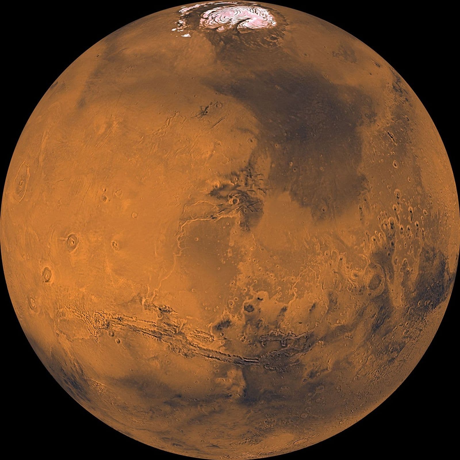 Direct observation
Processed data mosaic, not one photograph. Coverage gaps were interpolated, green was synthesized, illumination was normalized and color contrast was stretched to reveal surface differences.
NASA/JPL-Caltech/USGS ↗What this world is
Mars is smaller and less massive than Earth, with surface gravity about 38 percent as strong. Today it has a thin carbon dioxide atmosphere, polar ice, dust, volcanoes, canyons and no stable liquid water across the open surface.
Why it looks this way now
Early Mars had more internal heat, volcanic activity and surface water. As the small planet cooled, it lost a global magnetic field and much of its atmosphere. Low pressure and cold conditions now make stable surface liquid water difficult, while ancient river valleys and minerals retain the older story.
Where it sits
Mars is the fourth planet from the Sun, averaging about 228 million kilometres away. Its year lasts almost two Earth years, and its more elliptical orbit helps produce strong seasonal changes.
Swipe sideways to inspect the full map
The blue orbit, marker and name locate Mars without implying its live position today.
Earth is immediately inside; Jupiter is immediately outside. The lower sequence preserves all eight positions.
Read the numbers
Reference values retain their units, context, evidence state and published uncertainty.
Physical measurements
- Mean radiusglobal mean
- 3,389.5kmCalculated measurementAbout 53 percent of Earth's mean radius.
A global mean hides the Solar System's tallest volcano and deep impact basins.
Published uncertainty: ± 0.2 km
JPL tabulated uncertainty for the adopted mean radius.
- Massglobal mean
- 6.41691E23kgCalculated measurementAbout 10.7 percent of Earth's mass.
Inferred from gravitational effects on spacecraft and moons.
Published uncertainty: ± 3E19 kg
Converted from the uncertainty in the JPL 10^24 kilogram table.
- Mean densityglobal mean
- 3.9340g/cm³Calculated measurementAbout 3.9 times the density of water.
Lower than Earth, reflecting different proportions and compression of rock and metal.
Published uncertainty: ± 0.0007 g/cm³
Calculated from the adopted mass and volume.
- Reference gravityequatorial reference
- 3.71m/s²Calculated measurementAbout 38 percent of Earth's equatorial gravity.
A person's mass stays fixed, while their weight force becomes smaller.
No uncertainty published in this source table
JPL lists equatorial gravity without a table uncertainty; local terrain and crustal density alter the field.
- Temperaturesurface
- -153°CDirect observationA cold overview bound associated with polar winter conditions.
Temperature depends on surface, season, latitude, elevation and local time.
Approximate value
NASA overview bound. Actual readings depend strongly on season, latitude, elevation, local time and surface properties.
- Temperaturesurface
- 20°CDirect observationA favourable daytime value that can briefly feel mild by Earth standards.
Thin air stores little heat, so nearby air and night temperatures can still be very cold.
Approximate value
NASA overview bound for favourable daytime locations, not a global daily high.
Orbit and rotation
- Average distancerelative to the Sun
- 228,000,000kmCalculated measurementAbout 1.5 times Earth's average distance from the Sun.
The elliptical orbit makes sunlight change noticeably through the year.
Approximate value
Rounded average distance. Mars follows an elliptical orbit.
- Rotation periodrelative to distant stars
- 1.02595676Earth daysCalculated measurementA sidereal turn is about 24 hours 37 minutes.
A Martian solar day, called a sol, is slightly longer.
No uncertainty published in this source table
Sidereal rotation period in mean Earth days.
- Orbital periodrelative to distant stars
- 1.8808476Earth yearsCalculated measurementAbout 687 Earth days.
Longer seasons combine with a more elliptical orbit.
No uncertainty published in this source table
Sidereal orbital period in Julian years.
Atmosphere and inside
Atmosphere
The atmosphere is thin and dominated by carbon dioxide, with nitrogen and argon as the next largest listed components. Dust and water-ice clouds alter visibility and temperature, while pressure changes with elevation and season.
- Carbon dioxide95.3%
- Nitrogen2.7%
- Argon1.6%
Surface and interior
Orbiters map a basaltic, dusty surface with immense relief. Rovers and landers sample local rocks and weather directly. The crust, mantle and large liquid core are models constrained by gravity, rotation, heat flow and InSight's single seismic station.
- 1Liquid metal core
A large iron-rich liquid core whose size and state are constrained by InSight seismic and geophysical data.
Scientific model - 2Rocky mantle
A silicate layer that carried heat upward and fed the enormous volcanoes visible today.
Scientific model - 3Crust and surface
A basaltic crust beneath dust, impact terrain, volcanoes, canyons, sedimentary rock and water ice.
Scientific model
How we know
Laser altimetry and navigation fit the global shape. Radio tracking turns spacecraft motion into gravity and mass. Infrared radiometry retrieves temperatures, while seismic waves reveal boundaries that cannot be seen directly.
- 01Calculated measurement
Global topography and shape fitting
Laser altimetry maps surface height while spacecraft navigation supplies a reference frame. Scientists fit a global figure through rugged terrain.
Where this method stops
A mean radius smooths over Olympus Mons, deep basins and the north-south elevation contrast.
- 02Calculated measurement
Spacecraft radio tracking
Doppler and range measurements reveal how Mars accelerates orbiters, constraining gravity, mass, rotation and orbital parameters.
Where this method stops
The result depends on a dynamical solution that accounts for other bodies, spacecraft forces and reference frames.
- 03Direct observation
Infrared thermal mapping
Orbiters measure infrared energy emitted by the surface and atmosphere to retrieve temperature across place and time.
Where this method stops
A temperature retrieval needs calibration and an emissivity model; overview extremes do not describe every Martian day.
- 04Scientific model
Single-station seismology
InSight recorded marsquakes and impacts. Wave arrivals constrain crust, mantle and core models.
Where this method stops
One station gives less geometric coverage than a global network, so multiple interior models can fit parts of the data.
Evidence key
- Direct observation
- An instrument or sample recorded the phenomenon, with processing still disclosed.
- Calculated measurement
- Observed motion or signal is converted into a physical quantity using equations and reference constants.
- Scientific model
- A tested interpretation that fits observations but is not directly imaged or sampled.
- Vastward explanation
- Original beginner-facing synthesis, traceable to the source records but not itself a measurement.
- Artist visualization
- An interpretive image, not observational evidence.
Missions and instruments
Mars Global Surveyor
Mapped topography, gravity and surface properties, establishing a global geometric reference for Mars.
Official mission ↗- Mars Orbiter Laser AltimeterSurface elevation from the travel time of laser pulses.
Mars Reconnaissance Orbiter
High-resolution imaging, spectroscopy, radar and radio tracking reveal surface change, buried structure and gravity.
Official mission ↗- MRO radio scienceRange and Doppler shifts used for navigation, gravity and atmospheric occultation studies.
InSight
The lander recorded seismic waves and geophysical signals that transformed models of the Martian interior.
Official mission ↗- Seismic Experiment for Interior StructureGround motion from marsquakes, impacts and environmental sources.
Viking
Two orbiters and landers returned global imaging, weather and surface measurements; orbiter images underpin the hero mosaic.
Official mission ↗- Infrared Thermal MapperThermal emission from the surface and atmosphere in multiple infrared bands.
Official source trail
Links below are the exact records used for this profile. Access dates are retained with the content.
- 01
NASA Jet Propulsion Laboratory, Solar System Dynamics · dataset
Planetary Physical Parameters
- Source updated
- No source update date published
- Access checked
- 2026-07-29
- 02
NASA Science · official-page
Mars Facts
- Source updated
- No source update date published
- Access checked
- 2026-07-29
- 03
NASA/JPL-Caltech/USGS · image
Global Color Views of Mars
- Source updated
- 2024-11-06
- Access checked
- 2026-07-29
- 04
NASA Science · official-page
Mars Reconnaissance Orbiter
- Source updated
- No source update date published
- Access checked
- 2026-07-29
- 05
NASA Science · official-page
InSight
- Source updated
- No source update date published
- Access checked
- 2026-07-29
- 06
NASA Science · official-page
Viking 1 and 2
- Source updated
- No source update date published
- Access checked
- 2026-07-29
Continue exploring
Atlas is a starting point. Use these relationships to move into explanation, experiment and mission thinking.
Infer an unseen interior
Combine mass, radius and density before looking at the seismic model.
academyAvailable nowCompare a longer year
Connect solar distance, orbital speed and Mars's 687-day year.
academyTest a thin atmosphere
Explore why low pressure changes heat storage and liquid-water stability.
lab