
Object profile · MOON
Moon
Rocky natural satellite
Earth's nearest celestial neighbour, preserving a long record of impacts, volcanism and the early Solar System.
- Atlas data reviewed
- Editorial stage
- Published
- Visibility
- Public
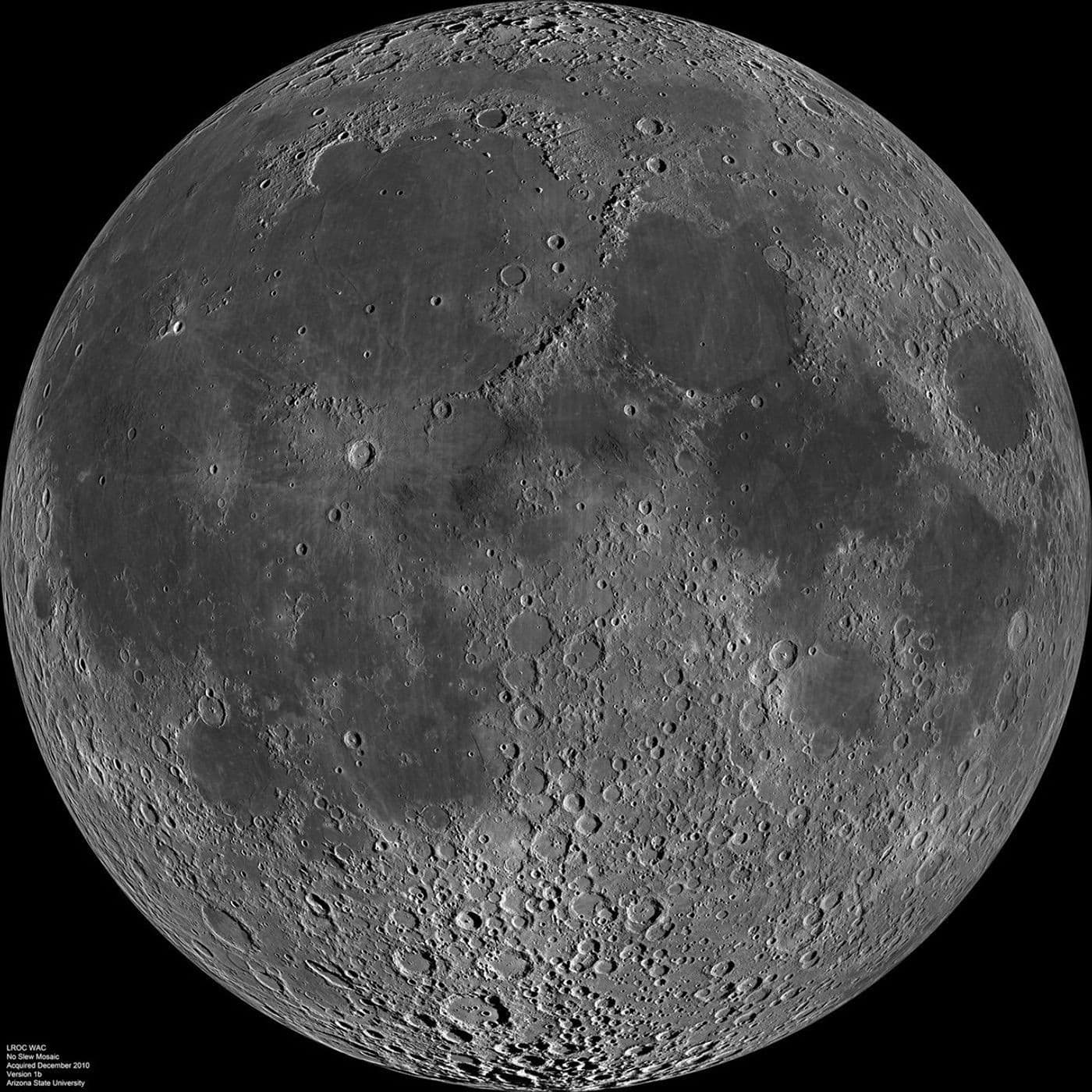 Direct observation
Spacecraft data mosaic, not one exposure. LRO imaged separate strips as the Moon rotated beneath it, so illumination varies across the assembled disk and the view is not a single instant.
NASA/GSFC/Arizona State University ↗What this world is
The Moon is a world, not just a light in the sky. It has mountains, plains, craters, a small metal core and an extremely thin exosphere. With almost no weather or liquid water at the surface, old impact scars remain visible for immense spans of time.
Why it looks this way now
A giant impact early in Solar System history is the leading formation model. The young Moon was much hotter and partly molten. As it cooled, dense material sank, lighter crust formed, lava flooded large basins and later impacts kept breaking the surface into regolith.
Where it sits
The Moon orbits Earth at an average distance of about 384,400 kilometres. Its orbit is elliptical and tilted, so distance, apparent size and position change through each month.
Swipe sideways to inspect the full map
Moon is 1 of 1 profiled Earth moons by distance, at a mean center distance of about 384,400 km.
The left panel locates Earth, dashed lines mark the scale change, and muted orbits and dots represent other profiled moons on the right. This is the innermost profiled moon in the system; it is the outermost profiled moon in the system.
Read the numbers
Reference values retain their units, context, evidence state and published uncertainty.
Physical measurements
- Mean radiusglobal mean
- 1,737.4kmCalculated measurementAbout 27 percent of Earth's mean radius.
A fitted global mean smooths over mountains and deep basins.
Published uncertainty: ± 0.1 km
JPL tabulated uncertainty for the adopted mean radius.
- Massglobal mean
- 7.34579E22kgCalculated measurementAbout 1.23 percent of Earth's mass.
Calculated from the gravitational parameter, not weighed directly.
Approximate value
Derived from JPL's lunar gravitational parameter and a conventional gravitational constant, then rounded.
- Mean densityglobal mean
- 3.344g/cm³Calculated measurementAbout 3.3 times the density of water.
Lower than Earth, consistent with a much smaller metal core.
Published uncertainty: ± 0.001 g/cm³
Calculated from the adopted mass and mean radius.
- Reference gravitysurface
- 1.62m/s²Calculated measurementAbout one sixth of Earth's surface gravity.
A 60 kg person's mass stays 60 kg, but their weight force is much smaller.
Approximate value
Representative mean surface gravity. Local values vary with terrain and subsurface mass.
- Temperaturesurface
- -173°CDirect observationA representative lunar night value near the equator.
Some permanently shadowed polar terrain becomes colder.
Approximate value
NASA overview value for nighttime equatorial temperature; permanently shadowed polar regions can be colder.
- Temperaturesurface
- 127°CDirect observationA representative sunlit equatorial value.
The surface heats and cools sharply because there is no thick atmosphere to spread heat.
Approximate value
NASA overview value for sunlit equatorial temperature.
Orbit and rotation
- Average distancesystem reference
- 384,400kmCalculated measurementRoughly 30 Earth diameters.
The real distance changes by tens of thousands of kilometres each orbit.
Approximate value
Rounded average Earth-Moon distance. The elliptical orbit produces a large monthly variation.
- Rotation periodrelative to distant stars
- 27.322Earth daysCalculated measurementOne turn relative to distant stars takes about 27.3 days.
Rotation and orbit stay synchronized, which keeps nearly the same side facing Earth.
Approximate value
Rounded sidereal rotation period.
- Orbital periodrelative to distant stars
- 27.322Earth daysCalculated measurementAbout 27.3 days relative to distant stars.
The Sun-Earth-Moon geometry makes the visible phase cycle about 29.5 days.
Approximate value
Rounded sidereal orbit period. The phase cycle from full Moon to full Moon is longer, about 29.5 days.
Atmosphere and inside
Atmosphere
The Moon has a surface-bounded exosphere rather than an atmosphere that behaves like Earth's. Its particles are so sparse that collisions are rare, winds do not form and fractions change with time and location.
- HeliumRelative abundance described; exact fraction not listed
- NeonRelative abundance described; exact fraction not listed
- ArgonRelative abundance described; exact fraction not listed
Surface and interior
Returned samples reveal surface materials directly. LRO maps the exterior in detail. The crust, mantle and small core are reconstructed by combining samples, gravity, rotation, heat flow and the Apollo seismic record.
- 1Small metallic core
A compact iron-rich center inferred from Apollo seismology, rotation and other geophysical data.
Scientific model - 2Mantle
A thick rocky layer that partly melted early in lunar history and supplied ancient volcanic plains.
Scientific model - 3Crust and regolith
A rocky crust covered by impact-fragmented dust and rubble called regolith.
Scientific model
How we know
Laser pulses time the Earth-Moon distance. Orbital tracking constrains gravity and mass. LRO laser altimetry maps shape, while infrared radiometry turns emitted energy into surface temperature estimates.
- 01Direct observation
Orbital laser altimetry
LOLA times laser pulses reflected from the surface. Many tracks build a global elevation and shape model.
Where this method stops
A global radius is fitted from many uneven terrain heights and depends on the adopted reference figure.
- 02Calculated measurement
Lunar laser ranging
Earth observatories time laser pulses bounced from retroreflectors left on the Moon, tightly constraining distance and orbital motion.
Where this method stops
A range is measured along a particular line of sight. Orbital parameters come from fitting many measurements to a dynamical model.
- 03Direct observation
Thermal radiometry
Diviner measures emitted infrared energy to map how lunar surface temperatures change with sunlight, terrain and local time.
Where this method stops
The instrument measures radiance. Temperature is retrieved using calibration and assumptions about how the surface emits heat.
Evidence key
- Direct observation
- An instrument or sample recorded the phenomenon, with processing still disclosed.
- Calculated measurement
- Observed motion or signal is converted into a physical quantity using equations and reference constants.
- Scientific model
- A tested interpretation that fits observations but is not directly imaged or sampled.
- Vastward explanation
- Original beginner-facing synthesis, traceable to the source records but not itself a measurement.
- Artist visualization
- An interpretive image, not observational evidence.
Missions and instruments
Lunar Reconnaissance Orbiter
Since 2009 LRO has mapped lunar shape, temperature, composition, illumination and radiation at high resolution.
Official mission ↗- Lunar Orbiter Laser AltimeterSurface elevation, slope, roughness and reflectance along orbital ground tracks.
- Diviner Lunar RadiometerReflected solar radiation and emitted infrared radiation used to retrieve surface temperature.
Apollo
Crewed landings returned samples and deployed instruments, including seismic stations and laser retroreflectors.
Official mission ↗- Apollo laser retroreflectorsRound-trip light time between Earth observatories and fixed lunar surface arrays.
Official source trail
Links below are the exact records used for this profile. Access dates are retained with the content.
- 01
NASA Jet Propulsion Laboratory, Solar System Dynamics · dataset
Planetary Satellite Physical Parameters
- Source updated
- No source update date published
- Access checked
- 2026-07-29
- 02
NASA Science · official-page
Moon Facts
- Source updated
- 2026-02-12
- Access checked
- 2026-07-29
- 03
NASA Science · official-page
Lunar Reconnaissance Orbiter
- Source updated
- No source update date published
- Access checked
- 2026-07-29
- 04
NASA Science Photojournal · image
Nearside Spectacular
- Source updated
- 2025-09-23
- Access checked
- 2026-07-30
Continue exploring
Atlas is a starting point. Use these relationships to move into explanation, experiment and mission thinking.
Try one-sixth gravity
Keep mass fixed and predict how weight, jumping and falling change.
academyAvailable nowSee orbit as continuous falling
Use the Moon to connect sideways motion, gravity and a closed orbit.
academyTime a laser pulse
Convert round-trip light time into distance and inspect the error budget.
lab